
Garmin GPSMAP 65s
4.6Editor score
Multi-band satellite support
2.6 inch color display
Barometric altimeter included
Finding a reliable handheld altimeter is essential for outdoor enthusiasts who need to track elevation changes during hikes, climbs, or road trips. These devices help you navigate safely and understand weather patterns by monitoring barometric pressure shifts over time.
We evaluated ten top-rated models ranging from simple analog gauges to advanced digital units with GPS and compass integration. Our comparison focuses on accuracy, build quality, battery life, and ease of use across various outdoor environments and conditions.
Each product selection highlights specific strengths and trade-offs to match different user needs and budgets. Please note that pricing fluctuates frequently, so verify current costs before making your final purchase decision online or in stores.
4.6Editor score
4.3Editor score

5.0Editor score
As an Amazon Associate we earn from qualifying purchases.
The following table provides a side-by-side overview of key specifications and features for each handheld altimeter model to help you quickly identify the best fit for your specific outdoor adventures and measurement needs.


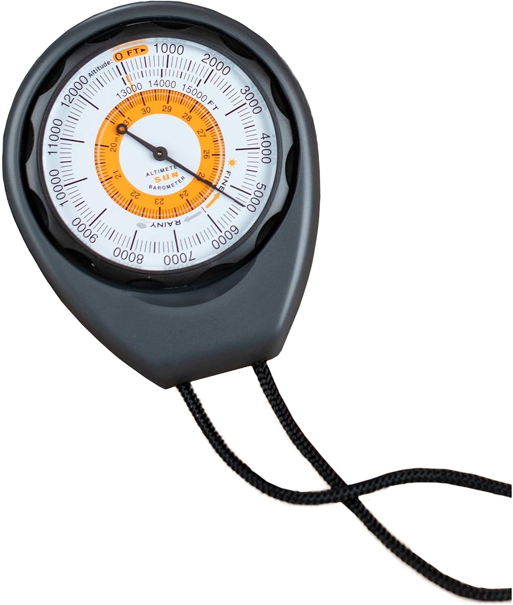
The Sun Company Altimeter 203 stands out as a reliable analog tool for hikers and campers needing elevation tracking without electronics. It holds a strong rating for its simplicity and rugged design suitable for outdoor use in varying weather conditions.
We may earn a commission when you buy through this link, at no additional cost to you.
Its battery-free mechanism adjusts based on surrounding barometric pressure ensuring it remains functional even when electronic components fail. The rugged ABS case protects the internal gauge from bumps while the included lanyard keeps it accessible on your gear.
While the altitude range tops at 15000 feet which may limit high mountain use it suffices for most hiking trails. The adjustable dial lets you calibrate for pressure systems enhancing accuracy without needing complex digital interfaces or power sources.
Buy this if you prefer straightforward analog tools for hiking camping or vehicle tracking. It pairs well with compasses thermometers for a full analog weather loadout that avoids battery dependency in remote locations.
This analog altimeter relies on barometric pressure adjustments rather than batteries ensuring it works indefinitely without power replacement.
The ABS case and included lanyard provide durability and portability making it easy to carry in a pocket or attach to gear.
We may earn a commission when you buy through this link, at no additional cost to you.
The BTMETER BT-100WM offers advanced multi-parameter tracking combining wind speed temperature and barometric pressure with altitude measurements in one device. Its digital precision and data logging capabilities appeal to serious outdoor enthusiasts needing detailed environmental metrics for analysis.
We may earn a commission when you buy through this link, at no additional cost to you.
With wind speed ranges covering 0.67 to 67.1 mph and altitude up to 19685 feet this unit handles diverse conditions. The LCD backlit screen ensures readability day or night while the tripod hole allows stable mounting for consistent readings during long monitoring sessions.
Data logging for 16 groups helps compare trends between temperature humidity and height over time enhancing safety planning. Auto shutdown preserves battery life though the reliance on power sources remains a consideration for extended remote trips without charging options.
Choose this if you need detailed weather and wind data alongside elevation for activities like sailing or drone driving. It supports technical users who value recorded metrics over simple analog indicators for outdoor planning.
Measures wind speed temperature and humidity alongside barometric pressure and altitude for a complete weather snapshot in the field.
Stores 16 groups of barometric pressure data allowing comparison of environmental trends to improve future trip safety.
We may earn a commission when you buy through this link, at no additional cost to you.
The Digital Compass Altimeter 8 in 1 consolidates multiple tools into a single compact device ideal for budget-conscious hikers needing basic elevation and direction data. It provides altitude up to 29500 feet with an electronic compass and thermometer for versatile outdoor utility.
We may earn a commission when you buy through this link, at no additional cost to you.
Its electronic backlight and multi function design make it suitable for mountain climbing and general hiking where carrying separate tools is inconvenient. The resolution of about 3.3 feet and wide pressure range allow monitoring of significant elevation changes across varied terrain easily.
While the rating reflects potential accuracy inconsistencies it remains a practical option for casual outdoor users prioritizing versatility over precision. The included lanyard aids portability though users should calibrate carefully for reliable navigation and weather tracking during critical trips.
Select this if you want an affordable all-in-one solution for basic hiking and camping. It simplifies gear loadouts though serious mountaineers might prefer dedicated higher accuracy instruments for demanding conditions.
Combines altimeter barometer compass thermometer and time into one unit reducing the need for multiple devices on the trail.
Measures altitude up to 29500 feet covering extreme elevation scenarios common in high mountain climbing expeditions.
We may earn a commission when you buy through this link, at no additional cost to you.
The Digital Altimeter 8 in 1 delivers comprehensive digital tracking with a wide altitude range covering from -2300 to 29500 feet for diverse terrain. Its digital features include an electronic compass barometer and thermometer making it a practical tool for general outdoor hiking adventures.
We may earn a commission when you buy through this link, at no additional cost to you.
The device offers clear displays with a five-second backlight ensuring visibility in low-light conditions during early starts or evening returns. Electronic compass adjustments based on magnetic fields help maintain direction while barometric readings provide useful weather pressure trend insights.
Users should note that while it covers broad ranges the accuracy may vary compared to premium units. Still it represents a solid middle ground for casual hikers needing digital feedback without spending heavily on high-end GPS integrated gear.
This unit suits those needing a lightweight digital altimeter for general outdoor sports. It simplifies navigation and weather monitoring though advanced users should verify calibration regularly for critical elevation data.
Eight functions including altitude barometer compass thermometer allow comprehensive environmental tracking in one compact handheld unit.
Covers from -2300 to 29500 feet supporting everything from deep valleys to high mountain peaks effectively.
We may earn a commission when you buy through this link, at no additional cost to you.
The Sun Company AltiLINQ is designed specifically for vehicle use allowing easy mounting on dashboards to track altitude changes during road trips. Its battery-free analog mechanism ensures reliability without power sources while the weather trend indicator provides useful pressure shift insights.
We may earn a commission when you buy through this link, at no additional cost to you.
The device includes hook-and-loop attachments enabling quick detachment for trail use after driving. This dual-purpose design makes it valuable for drivers traversing mountain roads who want real-time altitude feedback without complex digital interfaces or battery replacements.
Accuracy depends on manual calibration via the adjustable dial to account for local pressure systems. Though limited to 15000 feet it serves well for most vehicle elevation monitoring needs where simplicity and reliability matter most.
Choose this if you frequently drive in mountainous areas and need a simple reliable altitude tracker. It bridges vehicle tracking and handheld use effectively while remaining a versatile tool for any adventurer.
Quick detach mounting allows easy use on vehicle dashboards for road trip altitude tracking and trail portability.
Operates without batteries relying on barometric pressure adjustments ensuring continuous functionality without power dependency.
We may earn a commission when you buy through this link, at no additional cost to you.
The Handheld Clinometer serves as a sighting altimeter focused on measuring height and slope for forestry hiking and field work. Its aluminum alloy construction ensures waterproof and shockproof durability suitable for rugged outdoor environments where reliability is paramount.
We may earn a commission when you buy through this link, at no additional cost to you.
The deflection angle lens enables quick straight-forward reading of height and slope metrics in both inches and millimeters. A thick nylon carry bag protects the device during transport making it ideal for on-the-go professionals needing precise angle and height data.
While primarily designed for slope measurements it offers practical utility for backpackers monitoring steep terrain or tree heights. The compact palm size ensures it fits easily in pockets or gear without adding bulk to essential outdoor equipment.
This tool fits field workers hikers or explorers needing slope and height data. It prioritizes durability and simplicity over digital features offering a robust analog solution for outdoor measurement tasks.
Aluminum alloy construction ensures waterproof shockproof durability suitable for harsh outdoor field work conditions.
Deflection angle lens allows quick accurate reading of slope and height metrics for varied field tasks.
We may earn a commission when you buy through this link, at no additional cost to you.
The Garmin GPSMAP 65s stands as the premium option combining advanced GPS multi-band technology with a barometric altimeter for precise elevation tracking. Its large sunlight-readable color display and expandable satellite support make it ideal for challenging environments like forests or urban canyons.
We may earn a commission when you buy through this link, at no additional cost to you.
Features like 3-axis compass integration and federal public land mapping enhance navigation accuracy. The Explore website compatibility allows seamless route and statistics management making it a powerful tool for serious backcountry travelers needing reliable data.
While more expensive and dependent on battery life it offers unmatched accuracy and mapping capabilities. The multi-band technology ensures optimal positioning even in signal-poor areas where standard GPS devices might struggle during critical navigation tasks.
Choose this if you demand top-tier navigation and elevation accuracy for remote expeditions. It justifies the cost through advanced features and seamless software integration for comprehensive outdoor tracking solutions.
Expanded global navigation satellite systems provide optimal accuracy in challenging locations like dense forests or urban canyons.
Combines 3-axis compass with barometric altimeter to track elevation changes precisely and enhance navigation reliability.
We may earn a commission when you buy through this link, at no additional cost to you.
The Carabiner Altimeter Barometer combines three essential tools into a compact handheld device perfect for attaching to backpacks or belts. Its rugged ABS construction and built-in carabiner hook enable hands-free carrying ideal for climbers and hikers needing constant weather data.
We may earn a commission when you buy through this link, at no additional cost to you.
Weather forecasting predictions for up to 24 hours help plan fishing or camping trips safely. The versatile dashboard mount option adds value for drivers while the precision sensor ensures accurate pressure and temperature readings in extreme mountain climbing conditions.
This model excels in portability and ease of access without sacrificing critical weather data. Users appreciate the durable build that withstands outdoor impacts making it a practical gift for outdoor enthusiasts valuing convenience and reliability.
Select this if you prioritize hands-free carrying and weather insights during outdoor excursions. Its compact design ensures you always have essential elevation and temperature data available without bulky gear.
Integrated carabiner hook attaches directly to backpack straps allowing hands-free carrying during hiking climbing activities.
Premium ABS construction withstands harsh drops and impacts ensuring durability for extreme outdoor climbing adventures.
We may earn a commission when you buy through this link, at no additional cost to you.
The Pocket Altimeter is a professional-grade battery-free device built for precise height and slope measurements. Its compact lightweight design makes it ideal for architects travelers and explorers needing reliable inclinometer functions without electronic dependencies or complex interfaces.
We may earn a commission when you buy through this link, at no additional cost to you.
Constructed from aluminum alloy it offers compressive waterproof and shockproof durability ensuring longevity. The attached hand strap prevents loss while the soft fabric box provides safe storage when not in use for extended outdoor field work.
High accuracy ensures consistent measurement results across different times making it suitable for mapping or military equipment needs. Users should calibrate manually for best results though the clarity of the dial aids quick readings in the field.
Choose this if you need a reliable analog tool for slope and height analysis. It excels in professional or exploratory contexts where lightweight portability and accuracy are essential priorities.
Provides high accuracy measurements ensuring results remain consistent across different field uses or times.
Mini size and attached hand strap make it easy to carry and prevent losing during travel or exploration.
We may earn a commission when you buy through this link, at no additional cost to you.
The SUNROAD GPS Altimeter integrates three satellite systems for accurate positioning alongside barometric and altitude tracking. Its altitude target reminders and historical trend charts provide useful feedback for climbers monitoring elevation changes over specific time periods during outdoor sports.
We may earn a commission when you buy through this link, at no additional cost to you.
Features like built-in LED flashlight USB rechargeable battery and compass support offer practical convenience for night use and prolonged operation. The backlight function maintains visibility for five seconds ensuring clear readings in dark environments during critical navigation moments.
Users should note the lower rating suggests possible complexity or accuracy issues in certain conditions. However the multi satellite compatibility and rechargeable design make it a cost-effective choice for users prioritizing GPS integration over pure simplicity.
Select this if you want GPS altitude tracking with extra sport functions like pedometer and alarms. It serves active users needing comprehensive digital tools though regular calibration may be required for optimal accuracy.
GPS GLONASS and BeiDou compatibility ensures accurate positioning across varied environments for reliable outdoor sports tracking.
Altitude target reminders help monitor elevation changes at set intervals for improved safety during climbing activities.
We may earn a commission when you buy through this link, at no additional cost to you.
Choosing the right handheld altimeter involves balancing accuracy build quality and features to match your specific outdoor activities and navigation needs effectively.
Accuracy depends on sensor quality and calibration methods. Digital units with barometric sensors usually offer higher precision than analog ones but require calibration against known elevations for best results. Always check if the device allows manual adjustments to account for local pressure variations.
Prioritize models with adjustable dials or auto-calibration features to ensure reliable elevation readings during your adventures.
Power options range from battery-free analog mechanisms to digital units with replaceable or rechargeable batteries. Battery-free models offer endless uptime but may be less accurate. Digital devices need charging or battery swaps which could interrupt use in remote areas without power sources.
Select battery-free options for reliability or rechargeable digital models for advanced features depending on your trip length and access to charging.
Outdoor gear must withstand drops moisture and temperature changes. Look for rugged ABS or aluminum alloy housings that are waterproof and shockproof. A durable build ensures the device remains functional even after accidental drops during hiking or climbing activities.
Choose models with protective cases or reinforced designs to ensure longevity in harsh outdoor environments.
Different activities demand different altitude ranges. Climbers need devices covering up to 30000 feet while drivers might only need 15000. Resolution indicates precision in measurement such as 0.1 feet versus 3.3 feet which affects how detailed your elevation tracking can be.
Ensure the range and resolution match the highest elevations you expect to encounter during your outdoor activities.
Many units combine altimeters with compasses thermometers and barometers for comprehensive weather tracking. Some include GPS data logging or LED flashlights adding utility but also complexity. Decide which extra features align with your navigation needs without overwhelming the interface.
Multi-function tools reduce gear weight but verify that core altitude tracking remains precise and simple to operate.
User-friendly interfaces with clear displays and backlighting make reading data easy in all conditions. Complicated digital menus can hinder quick access to critical altitude info. Analog models offer simplicity while digital ones provide more data points at the cost of complexity.
Pick a model with intuitive controls and readable displays to ensure you can check elevation quickly when needed.
Lightweight compact designs with lanyards or clips facilitate easy carrying during hikes. Some devices offer dashboard mounts for vehicle tracking adding versatility. Ensure the unit fits comfortably in your gear or can be secured without hindering movement.
Look for included straps bags or clips to enhance portability and secure the altimeter during active use.
Prices vary widely based on technology and brand. Budget models offer basic functionality while premium units include GPS and advanced sensors. Evaluate if extra features justify the cost for your specific usage patterns and frequency of outdoor trips.
Balance your budget with required features to find the best value without unnecessary spending on unused capabilities.
To start using your altimeter calibrate it against a known elevation reference such as a trailhead sign or GPS location. This step aligns the barometric readings with actual terrain height ensuring accurate measurements throughout your journey.
For digital models turn the device on and allow it to stabilize in a steady environment before taking readings. Keep it away from direct heat sources or rapid temperature changes that might skew pressure sensors and compromise accuracy.
Store your altimeter in a dry protected place when not in use to prevent moisture damage. Regularly check batteries or recharge units before trips to ensure it is ready when needed for safety and navigation purposes.
A handheld altimeter measures air pressure which decreases as altitude increases. Barometric sensors convert this pressure into elevation readings often calibrated against sea level pressure. Analog versions use mechanical gauges while digital units rely on electronic pressure sensors.
Digital altimeters with electronic sensors generally offer higher precision and can show smaller elevation changes. Analog models are less prone to battery issues but may have larger tolerances. Accuracy also depends on calibration and environmental conditions affecting pressure.
Yes calibration is essential for accurate readings because weather changes affect air pressure. Calibrate at known elevations before each hike or trip. Some devices have auto-calibration but manual checks ensure better reliability during critical outdoor activities.
Many altimeters include barometers that track pressure trends to help predict approaching storms or clear skies. Sudden pressure drops may signal storms while rises indicate fair weather. Use these trends alongside forecasts for better trip planning.
Most hiking altimeters cover up to 15000 to 20000 feet which suits typical mountain trails. Extreme climbers may need ranges up to 30000 feet. Check the device specifications to ensure it meets your maximum elevation needs.
Battery life varies by usage but most digital models last weeks to months on a single charge or set of batteries. Auto-off features help conserve power. Rechargeable units may offer longer use between charges compared to replaceable options.
Yes but indoor pressure changes from HVAC or elevators may affect accuracy. Altimeters work best outdoors where pressure reflects actual terrain elevation. Indoor use may only be useful for testing or calibration reference points.
Prioritize barometer data for weather prediction and compass integration for direction. A backlight ensures visibility at night while rugged build protects against drops. Reliable calibration ensures elevation data supports safe route decisions.
We reviewed ten top handheld altimeters ranging from analog reliability to advanced GPS integration. The Sun Company Altimeter 203 offers durable simplicity while the Garmin GPSMAP 65s provides premium navigation for serious adventurers needing precision.
Prioritize accuracy build quality and battery life based on your specific hiking or climbing needs. A reliable altimeter enhances safety by providing critical elevation and weather data essential for planning outdoor routes and avoiding hazardous conditions.
Remember to check current prices and availability before purchasing as costs fluctuate regularly. Investing in the right altimeter ensures you stay oriented and informed during your outdoor expeditions with confidence.